Progetto Hebron
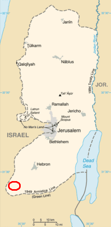
Mappa area progetto

Dove si svolge il progetto?
Alcune schede sulle localita’ dove si svolgono le attivita’ del progetto.
Fonte: Village Profiles The Applied Research Institute – Jerusalem
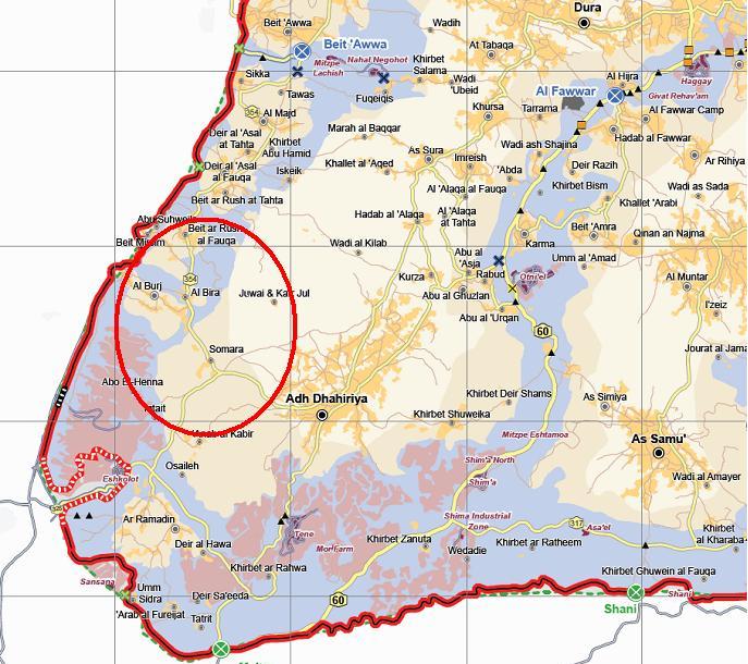
Beit Mirsim
Beit Mirsim is a village in the Dura area which is located 30 kilometers southwest of the city of Hebron in the southern part of West Bank. It is bordered by Beit ar Rush al Fauqa to the east and north, and Al Burj and the Segregation Wall to the west, and the south
The name Beit Mirsim derives from the Canaanite word “Qarya Safar” and “Beir sefer” which means an educational city.
The village was famous for ‘Place of Handal Prophet’; this however has been destroyed by the Israeli Occupation since the construction of the Segregation Wall. In addition there is the Beit Mirsim Hill which Canaanite Caves and Palaces, and ancient stone wells. In Abu Suhweila village, there are also ruins from the look Roman period.
Beit Mirsim lies on a total area of 1,500 dunums. 1,010 dunums are considered arable land; however, only 748.5 dunums are currently cultivated. There are about 0.5 dunums of greenhouses cultivating cucumbers
The Segregation Wall surrounds the village from three sides, the north, west and south. The construction of the Wall in the village began in 2004, a 3 km m portion (of the wire type) has been constructed on 80 dunums of confiscated village land and another 140 dunums will isolate behind the Wall. Also a further 2 km of Wall has been planned to be constructed on the village lands. About 400 olive, almonds and forest trees were destroyed while constructing the Wall. Five houses and five establishments were also demolished to construct the wall.
Somara
Somara is a Bedouin village in the Adh Dhahiriya area located about 20 kilometers southwest of Hebron city in southern West Bank. Somara is bordered by Adh Dhahiriya to the east, Wadi al Kilab village to the north, Al Burj and Al Bireh villages to the west and Anab al Kabir and Ar Ramadin villages to the south
Somara village is considered a rural area as it meets the criteria relevant to rural areas and has no local authority or services
According to Hebron localities surveys conducted by ARIJ in 2007, Somara residents are primarily dependent upon the agricultural sector and all residents in the village are engaged in agricultural activities. Somara village lacks any industrial or economic institutions. Data indicated that the most affected social groups in the village because of Israeli restrictions during the Second Intifada were:
1. Small farmers
2. Workers that had previously been employed in the Israeli labor market.
500 dunums are agricultural lands, and 480 dunums classified as forests and open space area.
Somara is agricultural village with 500 dunums of arable land, and as mentioned above, all of the residents are engaged in agricultural activities including planting field crops and vegetables. According to survey data, the cultivated area in Somara is 500 dunums, and about 200 dunums are uncultivated due to shortage of capital, shortage of water and infeasibility for agricultural activities. Most of agriculture in Somara is rain-fed, but ARIJ field survey data indicated that the farmers also depend on the water tankers to irrigate their crops. In spite of the 0.5 km of agricultural road in Somara, which is suitable for driving tractors and other agricultural machinery, it is insufficient and the village needs to construct new roads to cover the agricultural area of the village. Data collected from Somara village indicates that village residents depend on livestock rearing and dairy production and all village households’ rear and keep domestic animals. There are 1000 head of goats in the village
Al Burj
Al Burj is a village in the Dura area which is located 35 kilometers southwest of the City of Hebron, in the southern part of the West Bank. It is bordered by Al Bireh village to the east, Beit Mirsim to the north, Ar Ramadin to the south, and by the 1949 Armistice Line (the Green Line) to the west.
The total area of Al Burj village is approximately 9,910 dunums, of which 160 dunums are Palestinian built-up areas, 6,850 dunums are agricultural lands, 1,906 dunums can be categorized as forest, uncultivated, or public land, and 2,000 dunums which have been confiscated by the Israeli forces to build settlements and construct the segregation wall. The village council has a master plan for 348 dunums of village lands verified by the Ministry of the Local Government (MOLG).
According to one narrative, the history of Al Burj dates back to between 800- and 1000 years ago. According to this narrative the name of the village is derived from a castle established in 1254, called “Salah Al Deen Castle”. The castle was used as a monitoring tower for the western villages (today located inside the Green Line). The name of the village comes from the word “Burj” which means (in Arabic البرج ) “tower”. The origin of Al Burj residents is the Arabian Peninsula and eastern Jordan
In terms of historical sites, there are Al Burj Castle, and the Place of Abu Al Touq.
According to the Palestinian Ministry of Agriculture, the total area of Al Burj village is 9,910 dunums. 6,850 dunums are considered arable land; however, only 2,637 dunums are cultivated (see table 4). About 2,000 dunums of cultivable land are uncultivated, with farmers using it as pastures for livestock. Village officials cite the disuse of arable lands as a result of: water shortage, lack of manpower, and economic unfeasibility as a direct result of the occupation
Regarding the segregation wall, Israel started construction of the wall around the village in 2003. The wall surrounded the village from the west side with 6 km of the wall on the land of the village. Approximately 500 dunums of Al Burj land will be isolated behind the wall on completion of its proposed path. As a direct result of the wall, Israeli Forces have cut about 60 olive trees, and destroyed two houses and one kilometer of agricultural road. In addition, the farmers will lose the natural water spring “Bayara Al Burj,” which will be isolated behind the wall.
Adh Dhahiriya
Adh Dhahiriya is a Town in the Hebron Governorate, which is located 21 km to the south of Hebron city in southern part of the West Bank. Adh Dhahiriya is bordered by As Samu’ Town to the east, Rabud, Abu al ‘Asja, Kurza, Al Bireh, Al Burj (Dura city) to the north, Ar Ramadin village to the west and the 1949 Armistice Line (Green Line) to the south.
According to municipality data, Adh Dhahiriya was one of the main Canaanite cities, dating back to 5000 B.C. The Town gained significant importance from its location on the trade route between Egypt and Al Sham (Syria). Adh Dhahiriya’s name may be derived from the Canaanite word “Dhoher” ( رَ???? دَوه ), which means ‘post’, where it was a post and a connection point between Egypt and Al Sham. Another narrative suggests that the name Adh Dhahiriya is derived from “Al Thaher” ( اهر ة ???? الظ ), which means a ‘high hill’ because it appears in all areas as Al Thaher Baybars, a Mamluk Islamic leader, called it.
Today, Adh Dhahiriya is considered the southern gate of the West Bank and the connection point between the West Bank and Beersheba city, increasing its importance in trade and economics and becoming one of the most important trade centers in the Hebron Governorate
There are also a number of archeological and historical sites in the city: Doma, the Old City, Al Husn, Shuwaikah, Sammah, Kafr Gul, Caesareya and Anab al Kabir sites.
Adh Dhahiriya town lies on a total area of 98,000 dunums. 16,000 dunum are considered as build up area, 48,500 dunums are arable land; however, only 22,928 dunums are cultivated, while 25,572 dunums remain uncultivated
Adh Dhahiriya lies adjacent to the Green Line, and considerable suffering has taken place due to the Israeli occupation. There are four Israeli settlements surrounding the city: Eshkolot settlement to the southeast, Tene settlement to the south, Shima settlement to the east and the new Shima settlement to the south. Adh Dhahiriya is also surrounded by an Israeli bypass road, which runs from the west to the south and east. There are three permanent military checkpoints and one iron gate around Adh Dhahiriya, as well as numerous and unpredictable flying checkpoints elsewhere and one iron gate. Before the second Intifada, the Israeli occupation was confiscated approximately 30,000 dunum from the Adh Dhahiriya lands. Construction of the Segregation Wall began around Adh Dhahiriya in 2007. The Wall borders the town from two sides, stretching 12 km around the south and west of the city. In the construction of the wall, five housing units have been destroyed, seven housing units have received demolition orders and the Wall has isolated 70 people. According to municipal officials, 5,000 dunums of Adh Dhahiriya lands were confiscated for the Wall and a further 5,000 dunums have been isolated.
Al Bireh
Al Bireh is a village located in Dura area. It is located 19 km south-west of the city of Hebron in the southern part of the West Bank. It is bordered by Adh Dhahiriya (Somara village) to the east, Beit ar Rush al Fauqa to the north, Al Burj to the south and Adh Dhahiriya to the west
The Al Bireh village dates back to the Ottoman period. The name of the village, Al Bireh, was written on a board hanged at the entrance of the village. The residents of Al Bireh are originally from Dura city and from other villages destroyed by the Israeli Army.
There are also a few historical and archeological sites in the village such as Al Jrooam Roman site.
Al Bireh village lies on a total area of 4,000 dunums. 2,650 dunums are considered arable land; however, only 1,326.7 dunums are regularly cultivated. There are about 1.2 dunums of greenhouses, but no tunnels in Al Bireh village. About 0.5 dunums of this area is used for growing cucumber and another 0.5 dunums is used for growing tomatoes